
Skip to content
Political Maps

Political Maps

collection of maps of election results and political trends

  • 2016
  • 2012
  • 2008
  • 2004
  • 2000

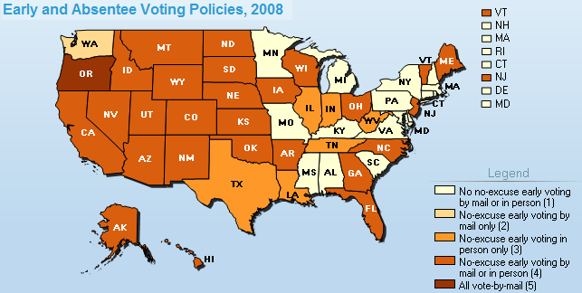
2008 Early and Absentee Voting Map

October 29, 2008

The Pew Center on the States has another great map on the 2008 election, this one focusing on early and absentee voting across the country. All states now have some form of early voting via no-excuse absentee voting and many more have in-person early voting.

  • Early and Absentee Voting Map

Post navigation

2008 Electoral Map Predictions: 10-28-2008
2008 Voter Registration Deadlines Map

Related Post

How Large Is the Divide Between Red and Blue America?

November 5, 2016

After decades of Republican victories, here’s how California became a blue state again

November 3, 2016

Kottke: How the Cretaceous coastline of North America affects US presidential elections

October 25, 2016
Political Maps

Political Maps

collection of maps of election results and political trends

Proudly powered by WordPress | Theme: Newsup by Themeansar.

  • Home
  • About
  • Archives
  • Privacy Policy
  • Sample Page
  • Sitemap